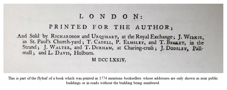
Most roads have always been named but individual buildings were not identified - unless they were particularly distinguished - until much more recently. There was no need; all local people will have known where to buy the items they needed in their vicinity.

Businesses would have signs indicating their trade hanging outside their premise, rather like pub signs today. The Red Lion originates from the time of King James I and VI of Scotland who apparently ordered that the heraldic red lion of Scotland be displayed on all buildings of importance. People could use these signs to describe addresses as best they could, for instance saying that they lived opposite or next door.

In his book, Diary of a Plague Year, Daniel Defoe (1660-1731) describes how people resorted to astrologers and fortune tellers to see if they might avoid the plague and that it became common to have signs and inscriptions set up on doors saying...here lives a fortune teller; here lives an astrologer.  

This is part of the flyleaf of a book which was printed in 1774  mentions booksellers whose addresses are only shown as near public buildings  or in roads without the building being numbered.

The Royal Mail

It was long-distance communications which led the need for more accurate addresses, especially with regard to the posting of letters. The Royal Mail has early origins – King Henry VIII established a ‘Master of the Posts’ in 1516 in order to ensure that his official communications could be delivered successfully to their recipients. In 1603, following his accession to the English throne as King James VI, Scottish King James I established a royal postal service between London and Edinburgh as it was important for him to keep communications channels open between the two kingdoms.

Of course, government officials and merchants also had a need for this sort of service and in 1635 King Charles I made the Royal Mail available to the public. The service was allocated to Thomas Witherings, a politician who died in 1651 and he opened the first post office at Bishopsgate Street the same year. Unlike today, postage was paid by the recipient – it was not until nearly 200 years later and the invention of the Penny Post by Rowland Hill in 1840 that people sending the letters were required to pay in advance.

How the numbering of houses began

As the population of London increased and more houses were built, more people became literate and started writing letters, so it became increasingly clear that it was necessary to have a more organised system for locating addresses. In 1708, the houses in Prescot Street, Goodman’s Fields are recorded as having been distinguished by numbers rather than signs and by the end of the century the numbering of houses seems to have become well-established. Numbers were done consecutively, rather than the odd and even numbers on separate sides of the road as is usual today.

The numbering system was haphazard to say the least; it was not organised or regulated so roads could be using different numbering systems at the same time. For example, the Postal Museum website says that Craven Street in the Strand had three sets of numbers at the same time in 1780. Street names could also be confusing. Our London Westminster and Middlesex Family History Society Parish Research Guides show thirty-three instances of Queen Street and although some of these will relate to the same road, they definitely were not all the same one. In a similar way, there were ten Red Lion Courts and another eleven Red Lion Yards. Once again, there was no regulation and builders or owners could name streets as they pleased.

Streets in North London in 1851

The London Westminster & Middlesex Family History Society has pubished several parish research guides. These have been designed by family historians for family historians and each guide contains a list of all of the streets of a given ancient parish which appear in the 1851 census. These guides can be obtained from the Parish Chest website.

Streets of St Anne Soho in 1851

Regulation started in 1855

It was not until 1855 that the power to control and regulate the naming of streets and the numbering of houses was set out in law with the passing of the Metropolitan Management Act. This gave the control and responsibility to the new Metropolitan Board of Works, which started work on simplifying house numbering and street names under the strong encouragement of the Post Office, who provided a list of the most urgent cases! One of the first things done was to record what was already there. Names of Streets and Places in the Administrative County of London was first published in 1855. This provided a base line from which changes could be noted.

It was in 1857 that ten central London districts were assigned a code, such as EC for Eastern Central and WC for Western Central. A large number of High Streets, King Streets and so on needed to be renamed so that no street name was duplicated within any one postal district. There was some public resistance to this but by 1871, some 4,800 street names had been changed and 100,000 houses renumbered.

In 1889 the administration of London, including responsibility for street naming and numbering, was taken over by the new London County Council (LCC). Names of Streets and Places in the Administrative County of London Including the Names of Blocks of Dwellings, Parks, and Open Spaces together with the Particulars of Orders Made Since 1856 Relative to Street Names and Numbers was published by the LCC in 1901, 1912, 1929 and 1955. These books record changes to street names and house numbers and a series of accompanying maps illustrate the alterations. The books list alterations and gives references to a series of corresponding plans which show the various changes in colour. These are kept at the London Metropolitan Archives (LMA), for example, ‘Renumbering 1-59 Peckham Rye, July 1927 (Plan 7476, Ref: LCC/AR/BA/05/336).

The 4th edition of Names of Street and Places, printed in 1955, cost £4 8s 0d (now £4.40) and there are several copies of it at LMA. One is in the LCC publications archive at Ref: LCC/PUB/01/374/3895 with another in the Greater London Council (GLC) publications archive at Ref: GLC/DG/PUB/01/061/0515. Other copies show up in other London libraries too. The LCC Publications archive contains supplements containing updates to the Names of Street and Places covering the dates 1882-1890, 1902-1903, 1916-1919-1911, 1913-1914, 1916-1927 and 1929-1939.


Local Authorities are given control from 1939

From 1939, the London Building Acts (Amendment) Act, 1939, meant that local authorities had the legal responsibility to ensure that streets are named and buildings are numbered and they have the powers to approve or reject building and street address suggestions submitted by developers. This is still the case to this day. Consistent naming and numbering is important for the public, postal services and the emergency services to find properties efficiently and there are rules to follow. For example, a new street should be numbered with the even numbers on the right side and the odd numbers on the left, except in a cul-de-sac where consecutive numbering in a clockwise direction is preferred; number one should be at the end of the road nearest to the town or village centre; roads must start with number one and it is not permitted to leave out numbers, such as thirteen from a sequence because this has caused confusion for those trying to find an address. Road-naming has many rules too; for example, any road named ‘Hill’ must actually be on a hill and no road name can start with ‘The’. You can read more about the regulations on the websites of most London Boroughs. The City of London has an interesting thirty-four page Street Numbering and Naming Advice Note here: https://www.cityoflondon.gov.uk/assets/Services-Environment/street-naming-and-numbering-advice-note-2021-feb.pdf

The GLC inherited overall control of street-naming within London from the LCC in 1965. Central control was still required to ensure that street names were not duplicated across boroughs. The responsibility for this was given to the Building Regulation Division of the Architect’s Department, which also included approving numbering schemes and style of addresses and for naming blocks of flats. Alterations were recorded on Ordnance Survey 1:1250 maps. Changes in name or layout of streets, or new developments, were added by hand. Colour coding helped: red was used for changes of name with a number indicating that a case file should be consulted, yellow for road closures and green for new developments. However, these additions are generally not dated. These maps appear in the ‘Architect’s Department: Building regulations division – street-naming section’ at LMA, Ref: GLC/AR/BR/SN.

A different part of the GLC archive at LMA contains two amended interleaved copies of the Names of Streets and Places which were kept up-to-date with manuscript additions until 1985 (Ref: GLC/AR/BR/SN/05). The GLC archives has A Supplement to the Names of Street and Places in the Former Administrative County of London 1955-1966 (published in 1967) which originally cost ten shillings (now 50p). This is at LMA, Ref: GLC/DG/PUB/01/002/0136.

The Post Office

The Post Office has no control over street-naming or numbering but does issue postcodes. These were introduced in the 1960s to facilitate the mechanised sorting of mail. At the Postal Museum there is a booklet called GPO Notes on Street Naming and Numbering of Premises (1966, Ref: POST 17/159), which says: The Post Office has no power to insist upon the use of house numbers and street names in postal addresses but once Local Authorities, in fulfilling their statutory authority, complete the task of naming of streets, numbering of premises and insisting upon the exhibition of numbers a great deal can be done by the Post Office in persuading users of the post to help.

Help with changes of road names

There is an online resource which can help with road-name changes. Old to New Street Names details some 23,000 changes in road names which have occurred from 1857 to 1929 and from 1929 to 1945. (A fuller version of this is available as an ebook for £6.99.) By the same author is a finding aid for London Postal Districts (which were introduced in 1857), useful for Londoners but surely crucial to those who are researching ancestors from further away. Another page lists every street in London in 1938, which is taken from the London Post Offices and Streets of that year. All of these can be found on the ‘London Miscellany’ page of this website: https://www.maps.thehunthouse.com/London_Miscellany.htm

Looking in Islington? You are in luck!

If you are looking for roads in Islington you are particularly lucky! Streets with a Story - The Book of Islington was written by Eric A Willats and first published by Islington Local History Education Trust in 1986. A revised digital edition was published in 2017 by Islington Heritage Service. This delightful and informative work is surely a must for anyone researching family who lived in Islington. It contains an alphabetical list of all streets, squares, places, terraces, tenements and blocks of flats both past and present. The history of these places is detailed where known, along with any road name changes and famous residents are noted. There is a link on the local history page of Islington Local History Centre online here: https://friendsofim.com/2021/04/08/streets-with-a-story-the-book-of-islington/

This article was contributed by Elizabeth Burling from London Westminster and Middlesex Family History Society.
Website by Beachshore